Bozeman, Montana
| Bozeman, Montana | |||
|---|---|---|---|
| — City — | |||
|
|||
 |
|||
| Coordinates: | |||
| Country | United States | ||
| State | Montana | ||
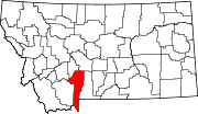
| County | Gallatin | ||
| Government | |||
| - Mayor | Jeff Krauss | ||
| Area | |||
| - Total | 20.3 sq mi (32.6 km2) | ||
| - Land | 20.3 sq mi (32.6 km2) | ||
| - Water | 0.0 sq mi (0 km2) | ||
| Elevation | 4,820 ft (1,461 m) | ||
| Population (2007) | |||
| - Total | 37,981 | ||
| - Density | 1,358/sq mi (843.8/km2) | ||
| Time zone | MST (UTC-7) | ||
| - Summer (DST) | MDT (UTC-6) | ||
| ZIP codes | 59715, 59717-59719, 59771-59772 | ||
| Area code(s) | 406 | ||
| FIPS code | 30-08950 | ||
| GNIS feature ID | 0769173 | ||
| Website | www.bozeman.net | ||

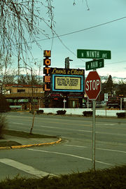
Bozeman is a city in and the county seat of Gallatin County, Montana, United States,[1] in the southwestern part of the state. With a population of 27,509 at the 2000 census, Bozeman is the fifth largest city in the state. It is the principal city of the Bozeman micropolitan area, which consists of all of Gallatin County.[2]
The city is named after John M. Bozeman, founder of the Bozeman Trail. Located in the fastest-growing county in the state [1], Bozeman was elected an All-America City in 2001 by the National Civic League.[3] Bozeman residents are known as Bozemanites.
Bozeman is home to Montana State University - Bozeman. The local newspaper is the Bozeman Daily Chronicle, and the city is served by Gallatin Field Airport.
Contents |
History
Early History
For thousands of years, Native Americans tribes including the Shoshone, Nez Perce, Blackfeet, Flathead, Crow Nation and Sioux traveled through the area, called the "Valley of the Flowers" [4], although the Gallatin Valley was home to the Crow Indians.
19th century
William Clark visited the area in July 1806 as he traveled east from Three Forks along the Gallatin River. The party camped 3 miles (4.8 km) east of what is now Bozeman, at the mouth of Kelly Canyon. The journal entries from Clark's party briefly describe the future city's location. [2].
In 1863, John Bozeman, along with a partner named John Jacobs, opened the Bozeman Trail, an offshoot from the Oregon Trail leading to the mining town of Virginia City through the Gallatin Valley and the future location of the city of Bozeman.
John Bozeman, with Daniel Rouse and William Beall platted the town in 1864, stating "standing right in the gate of the mountains ready to swallow up all tenderfeet that would reach the territory from the east, with their golden fleeces to be taken care of...". Red Cloud's War closed the Bozeman Trail in 1868, but the town's fertile land attracted permanent settlers.
In 1866, Nelson Story arrived with 3,000 head of longhorn cattle, eluding both Native Americans and the U.S. Army, who tried to turn Story back for safety reasons. Those cattle formed the first herd in Montana's cattle industry.
Fort Ellis was established in 1867 by Captain R. S. LaMotte and two companies of the 2nd Cavalry, after the mysterious death of John Bozeman near Yellowstone and considerable political disturbance in the area led local settlers and miners to feel a need for added protection. The fort, named for Gettysburg casualty Colonel Augustus Van Horne Ellis, was decommissioned in 1886 and few remains are left at the actual site, now occupied by the Fort Ellis Experimental Station of Montana State University [3]. In addition to Fort Ellis, a short-lived fort, Fort Elizabeth Meagher (also simply known as Fort Meagher), was established in 1867 by volunteer militiamen. This fort was located eight miles (13 km) east of town on Rocky Creek.
Northern Pacific Railway tracks finally reached the town in 1883. By 1900, Bozeman's population reached 3,500.
Montana State University - Bozeman was established in 1893 as the state's land-grant college, then named the Agricultural College of the State of Montana. By the 1920s, the institution's preferred name was Montana State College until 1965, when it was changed to Montana State University.[5]
20th century
The first Federal Building and Post Office was built in 1915. Many years later, while empty, it was a film location, along with downtown Bozeman, in A River Runs Through It (1992) by Robert Redford, starring Brad Pitt. It is now used by HRDC, a community organization.
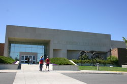
The University's Museum of the Rockies was put on the map by famed paleontologist Jack Horner.
Residents and visitors enjoy access to skiing at the Big Sky Ski Resort, 40 miles (64 km) south of Bozeman, although many locals prefer the closer and less expensive Bridger Bowl Ski Area, approximately 15 miles (24 km) to the northeast. Plentiful recreational activities and the free marketing the area received from films set nearby, such as A River Runs Through It and The Horse Whisperer have combined to bring a steady influx of new residents and visitors.
21st century
While Bozeman grew at a fairly rapid pace in comparison to the rest of Montana for the past 40 years, in recent years Bozeman experienced significant growth. The city continues to attract new residents due to quality of life factors, scenery, and nearby recreation.
Geography and climate
Bozeman is located at (45.677890, -111.047274),[6] at an altitude of 4,820 feet (1,468m).[7] The Bridger Mountains are to the north-northeast, the Tobacco Root Mountains to the west-south-west, the Big Belt Mountains and Horseshoe Hills to the far north, the Hyalite Peaks of the northern Gallatin Range to the south and the Spanish Peaks of the northern Madison Range to the south-southwest. Bozeman is east of the continental divide, and Interstate 90 passes through the city. It is 84 miles (135 km) east of Butte, 125 miles (201 km) west of Billings, and 93 miles (150 km) north of Yellowstone National Park.
According to the United States Census Bureau, the city has a total area of 12.6 square miles (32.6 km²), all of it land.
The climate in Bozeman and the surrounding area receives significantly higher rainfall than much of the state, up to 24 inches (610 mm) of precipitation annually vs. 8-12" (20–30 cm) common throughout much of Montana east of the Continental Divide. [4]. Combined with fertile soils, plant growth is relatively lush. This undoubtedly contributed to the early nickname "Valley of the Flowers" and the establishment of MSU as the state's Agricultural College. Bozeman has cold, snowy winters and relatively warm summers, though due to elevation, temperature changes from day to night can be significant.
| Climate data for Bozeman, Montana | |||||||||||||
|---|---|---|---|---|---|---|---|---|---|---|---|---|---|
| Month | Jan | Feb | Mar | Apr | May | Jun | Jul | Aug | Sep | Oct | Nov | Dec | Year |
Demographics
| Historical populations | |||
|---|---|---|---|
| Census | Pop. | %± | |
| 1870 | 168 |
|
|
| 1880 | 894 | 432.1% | |
| 1890 | 2,143 | 139.7% | |
| 1900 | 3,419 | 59.5% | |
| 1910 | 5,187 | 51.7% | |
| 1920 | 6,183 | 19.2% | |
| 1930 | 6,855 | 10.9% | |
| 1940 | 8,665 | 26.4% | |
| 1950 | 11,325 | 30.7% | |
| 1960 | 13,361 | 18.0% | |
| 1970 | 18,670 | 39.7% | |
| 1980 | 21,645 | 15.9% | |
| 1990 | 22,660 | 4.7% | |
| 2000 | 27,509 | 21.4% | |
| Est. 2007 | 37,981 | 38.1% | |
| source:[8][9] | |||
As of the census[10] of 2000, there were 27,509 people, 10,877 households, and 5,014 families residing in the city. The population density was 2,183.8 people per square mile (843.0/km²). There were 11,577 housing units at an average density of 919.0/sq mi (354.8/km²). The racial makeup of the city was 94.73% White, 0.33% African American, 1.24% Native American, 1.62% Asian, 0.07% Pacific Islander, 0.54% from other races, and 1.47% from two or more races. Hispanic or Latino of any race were 1.59% of the population.
There were 10,877 households out of which 22.3% had children under the age of 18 living with them, 36.0% were married couples living together, 7.3% had a female householder with no husband present, and 53.9% were non-families. 30.4% of all households were made up of individuals and 6.7% had someone living alone who was 65 years of age or older. The average household size was 2.26 and the average family size was 2.85.
In the city the population was spread out with 16.0% under the age of 18, 33.0% from 18 to 24, 28.6% from 25 to 44, 14.4% from 45 to 64, and 8.0% who were 65 years of age or older. The median age was 25 years. For every 100 females there were 111.2 males. For every 100 females age 18 and over, there were 112.6 males.
The median income for a household in the city was $32,156, and the median income for a family was $41,723. Males had a median income of $28,794 versus $20,743 for females. The per capita income for the city was $16,104. About 9.2% of families and 20.2% of the population were below the poverty line, including 14.8% of those under age 18 and 4.4% of those age 65 or over.
Media
Newspapers and Magazines
The Bozeman Daily Chronicle is the local daily paper. Bozeman Magazine is a free monthly publication. Outside Bozeman Magazine is a quarterly journal dedicated to local outdoor recreation.
AM radio
- KBOZ 1090, (Talk/Personality), Reier Broadcasting Company
- KOBB 1230, (sports talk), Reier Broadcasting Company
- KPRK AM 1340, (Classic Hits), GapWest Broadcasting
- KMMS 1450, (News/Talk), GapWest Broadcasting
FM radio
- KGLT 91.9, (Variety), Montana State University-Bozeman
- KOBB-FM 93.7, (Oldies), Reier Broadcasting Company
- KMMS-FM 95.1, (Adult Album), GapWest Broadcasting
- KISN 96.7, (Top 40 (CHR)), GapWest Broadcasting
- KOZB 97.5, (Classic rock), Reier Broadcasting Company
- KBOZ-FM 99.9, (Country Music), Reier Broadcasting Company
- KXLB 100.7, (Country Music), GapWest Broadcasting
- KBMC (FM) 102.1, (Variety), Montana State University-Billings
- KZMY 103.5, (Hot Adult Contemporary), GapWest Broadcasting
- KBZM 104.7, (Classic Hits), Orion Media LLC
- KKQX 105.7, (Classic Hits), Orion Media LLC
- KSCY 106.9, (Country Music), Orion Media LLC
Television
- KTVM 6 NBC, Bonten Media Group
- KBZK 7 CBS, Evening Post Publishing Company
- KUSM 9 PBS, Montana State University
Transportation
Since 2006, Bozeman has a public bus transportation system called Streamline. Streamline operates four routes covering most of the Bozeman area. This includes the University, Hospital, Mall, Main Shopping areas, and downtown. The system is funded by a variety of Federal, State, and local sources. The Associated Students of Montana State University is one of the contributors to the system. Because of this funding, consumers are not charged to ride the bus service.
The area is also served by Gallatin Field Airport. The airport is northwest of Bozeman, near Belgrade, Montana. It primarily serves Bozeman, Big Sky, West Yellowstone and Yellowstone National Park, though there is also a smaller airport in West Yellowstone. It is one of three major regional airports serving Southwestern Montana.
Notable natives and residents
- Loren Acton, astronaut and physicist[11]
- Conrad Anker, author, ice climber and high altitude mountaineer
- John Baden, economist
- John Bohlinger, Lieutenant Governor of Montana
- John Bozeman, pioneer and founder of the Bozeman Trail.
- Dorothy Bradley, former state legislator and gubernatorial candidate[12]
- Brannon Braga, writer and producer of Star Trek television shows and films
- Will Brooke, former chief of staff of Conrad Burns
- Deborah Butterfield, sculptor known for use of horses in artwork
- Gary Cooper, actor, attended Gallatin Valley High School in Bozeman[13]
- Don G. Despain, botanist, ecologist, and fire behavior specialist
- Daniella Deutscher, actress
- Gustavus Cheyney Doane, member of Washburn-Langford-Doane Expedition 1870 and buried in Sunset Hills Cemetery, Bozeman
- Diana L. Eck, Professor of Comparative Religion at Harvard University
- Zales Ecton, Republican politician in the 1930s
- Pablo Elvira, opera singer
- Charles S. Hartman, United States Congressman from Montana
- Jack Horner, preeminent paleontologist upon whom the main character, Dr. Alan Grant, in the book and film Jurassic Park was patterned
- Landon Jones, journalist and author
- Stan Jones, Libertarian Party candidate for Montana governor and United States Senator
- Ryan Jordan, a pioneer of the modern-day ultralight backpacking movement and founder of Backpacking Light Magazine
- Dale W. Jorgenson, Harvard University professor and economist
- Donna Kelley, former CNN anchor and current KBZK anchor.
- Vanessa Kerry, daughter of John Kerry
- Jane Lawrence, actress and opera singer
- Alex Lowe, famous ice-climber and alpinist
- Darren Main, yoga instructor
- Heather McPhie, Freestyle skier, member of 2010 US Olympic Team
- Ben Mikaelsen, author[14]
- Greg Mortenson, humanitarian and founder of the Central Asia Institute
- Phil Olsen, former National Football League lineman
- Christopher Parkening, guitarist
- Robert M. Pirsig, author and past instructor of English and rhetoric at Montana State University
- David Quammen, long-time columnist for Outside magazine, and author
- Elizabeth Clare Prophet, co-founder of Church Universal and Triumphant
- Scott Sales, former Speaker of the Montana House of Representatives
- Willie Saunders, Bozeman-born Canadian Horse Racing Hall of Fame jockey, won U.S. Triple Crown
- Jan Stenerud, Member of the Pro Football Hall of Fame, AFL and NFL place-kicker for Kansas City Chiefs, Green Bay Packers and Minnesota Vikings. Winner in Super Bowl IV
- Kevin Sweeney, former quarterback for the Dallas Cowboys
- Sidney Runyan Thomas, judge of the United States Court of Appeals for the Ninth Circuit
- Julia Thorne, writer and ex-wife of 2004 Democratic Presidential candidate John Kerry
- Ted Turner, entrepreneur (Ted's Montana Grill) and founder of cable television empires including CNN and TBS[15][16]
- Kathy Tyers, writer particularly known for her contribution to the Star Wars series
- Peter Voulkos, ceramic artist
- Sarah Vowell, author, regular on This American Life, and voiceover actress, most recognized from The Incredibles [17][18]
- Dave Walker, musician
- Bill Yellowtail, former Montana state senator
- Casey Anderson, Grizzly Bear expert and frequent guest on National Geographic Wild. Husband of actress Missi Pyle.[19]
References in popular culture
- The movie Star Trek: First Contact established Bozeman as the site of first contact between Vulcans and humans, an event subsequently referenced in Star Trek: Enterprise episodes "Carbon Creek" and "Desert Crossing", which specifically named the city as the location. A Starfleet starship named for the city, USS Bozeman, appears in the Star Trek: The Next Generation episode "Cause and Effect".
- In the television show CSI: Crime Scene Investigation, Las Vegas Crime Scene Investigator Level 3 Catherine Willows is originally from Bozeman. Its spinoff show CSI: NY also includes a Bozeman native, Detective Lindsay Monroe.
- The film "A Plumm Summer" was shot primarily in Bozeman, and featured two local actors, Ben Trotter and John Hosking, as well as a host of local extras.
- Bozeman was also featured in the movie Supervolcano, where it is destroyed by an eruption at Yellowstone National Park.
- In The Silence of the Lambs, FBI trainee Clarice Starling recounts elements of her childhood to Hannibal Lecter, including mention that she was sent to "the Lutheran orphanage in Bozeman".
- Bozeman is the hometown of Dale, a character from Heroes, featured in the episode "Unexpected".
- Montana State University in Bozeman provides a key setting in Robert Pirsig's novel Zen and the Art of Motorcycle Maintenance; the narrator was a professor teaching English composition while developing his philosophical ideas.
- The members of the noise rock group Steel Pole Bath Tub are originally from Bozeman. They wrote a song titled "Bozeman" on their third album, The Miracle of Sound in Motion.
- Bozeman is also the hometown of Roy Eberhardt, the main character in the best-selling novel Hoot.
- In the film, "A River Runs Through It" a scene was filmed in the Student Union of Montana State University, Bozeman. Much of the movie was filmed near Bozeman, on the Gallatin and Yellowstone Rivers, though the story was set in Missoula.
- The NorthEastern Jamband Strangefolk's song "Westerly" content was written about events that happened at the Filling Station off of their famous "Weightless in Water" recording
- In an episode of the television sitcom The Big Bang Theory, Sheldon moves to Bozeman after his Pasadena apartment is broken into. He moves back to California after being robbed upon his arrival.
- Bozeman is referenced in the movie "Shooter" starring Mark Wahlberg.
Business and Industry
Bozeman's largest employers include Montana State University as well as at least eight high-tech companies which are engaged in research or production of laser optic equipment, over a dozen bio-tech companies, and several large software companies.[20] Nationally-known high tech companies based in Bozeman include Right Now Technologies,[21] and ILX Lightwave Corporation.[22] Other nationally-known companies based in Bozeman include Gibson Guitar Corporation and Mystery Ranch Backpacks.[23]
Points of interest
- Montana Arboretum and Gardens
- Museum of the Rockies
- Bridger Bowl Ski Area
- Yellowstone National Park
- Montana State University
- American Computer Museum
- Big Sky Resort
- Moonlight Basin
- Pioneer Museum of Bozeman
- Gibson Guitar Factory
References
- ↑ "Find a County". National Association of Counties. http://www.naco.org/Template.cfm?Section=Find_a_County&Template=/cffiles/counties/usamap.cfm. Retrieved 2008-01-31.
- ↑ Update of Statistical Area Definitions and Guidance on Their Uses, Office of Management and Budget, 2007-11-20. Accessed 2008-12-10.
- ↑ http://www.ncl.org/aac/past_winners/past_winners.html
- ↑ http://www.mtstandard.com/highwaystoadventure/lewisclark.html
- ↑ Montana State University History. Web page accessed May 30, 2009.
- ↑ "US Gazetteer files: 2000 and 1990". United States Census Bureau. 2005-05-03. http://www.census.gov/geo/www/gazetteer/gazette.html. Retrieved 2008-01-31.
- ↑ U.S. Geological Survey Geographic Names Information System: Bozeman, Montana
- ↑ Moffatt, Riley. Population History of Western U.S. Cities & Towns, 1850-1990. Lanham: Scarecrow, 1996, 128.
- ↑ "Subcounty population estimates: Montana 2000-2007" (CSV). United States Census Bureau, Population Division. 2009-03-18. http://www.census.gov/popest/cities/files/SUB-EST2007-30.csv. Retrieved 2009-05-07.
- ↑ "American FactFinder". United States Census Bureau. http://factfinder.census.gov. Retrieved 2008-01-31.
- ↑ MSU Physics Department
- ↑ "Ex-lawmaker Dorothy Bradley named to NorthWestern board, Missoulian Online, April 22, 2009, accessed June 29, 2009
- ↑ "Gary Cooper" Cool Montana Stories Montanakids.com
- ↑ Author Ben Mikaelsen
- ↑ Turner Enterprises, Ranches FAQ
- ↑ "Ted Turner grand marshal of Livingston parade" Great Falls Tribune, June 26, 2009
- ↑ http://transom.org/talk/specialguests/sarahvowell.html
- ↑ http://www.identitytheory.com/people/birnbaum66.html
- ↑ "Meet Casey Anderson". Los Angeles Times. 2009-05-03. http://latimesblogs.latimes.com/unleashed/2009/05/meet-casey-anderson-and-his-best-friend-an-800pound-bear.html. Retrieved 2010-04-29.
- ↑ "High-tech clusters spur growth in western Montana". Federal Reserve Bank of Minneapolis. http://www.minneapolisfed.org/publications_papers/pub_display.cfm?id=2831. Retrieved 2010-07-11.
- ↑ "Right Now Technologies". http://www.rightnow.com/. Retrieved 2010-07-11.
- ↑ "ILX Lightwave". http://www.ilxlightwave.com/. Retrieved 2010-07-11.
- ↑ "Mystery Ranch Backpacks". http://mysteryranch.com/site/index.html. Retrieved 2010-07-11.
Further reading
- Smith, Phyllis (1996). Bozeman and the Gallatin Valley. A History. Helena, MT: Falcon Press Publishers. ISBN 1560445408.
External links
- City website
- Chamber of Commerce
- Convention and Visitors' Bureau
- Bozeman Public Schools
- Gallatin County Emergency Management
|
|||||||||||||||||||||||
|
|||||||||||||||||